History
Click on an image below to read more in a PDF file or another page on this website.
|
|
|
 |
Censuses were carried out every 10 years to keep track of the country’s population. Census records indicate where someone lived, their name, gender, age on the date of the census, occupation and birthplace. The records also show with whom the person was living or visiting on the night of the census. From 1851 the person's relationship to the head of the household and marital status and birthplace are also shown. Alan and Val Hunt are transcribing the census records for Stanton-on-the-Wolds, for 1841 onwards, and have made them available via this website. |
|
|
|
 |
The war memorial was erected in 1920 near the north-west corner of All Saints Parish Church by a parish subscription. As a Millennium project, it was cleaned and re-sited in the memorial area outside the old churchyard. The simple carved stone cross stands above a plinth that is inscribed with the names of the three men from the parish who fell in the First World War. Joseph Hatherley, Leonard Hatherley and Tom Henry Kemp The War Memorial was Grade II listed as a building of Special Architectural or Historic Interest on April 12, 2019. |
|
|
|
 |
Gill Woodford, née Ashton, was born in Stanton on 1947 and has lived here all her life. In this item she reflects on her childhood living on Stanton Lane. Her father, Dick Ashton, ran the family's Ashton Farm Nursery with her uncle. Her mother, Rene Ashton, worked in Stanwolds Kennels, then on the Plumtree manual telephone exchange (on the corner of Rose Grove) and later as a receptionist for Dr Russell. |
|
|
|
 |
The Hatherley family lived in a thatched cottage on Thurlby land in Stanton from 1879. They had fourteen children, but some were lost in tragic circumstances. Two Hatherley sons are commemorated on the war memorial, one girl died in infancy, a second died at 18. Another son was killed in a mining accident in Swanwick New Colliery, near Alfreton. |
|
|
|
") |
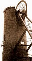
In the 1930s it became necessary to erect a water tower (opposite Stanton Parish Church) and construct a pumping station near the railway station to pump water to the storage tank at the top of the tower. A spiral structure of 115 steps led to the summit through a shaft in the centre of the tanks. In order to ensure a firm foundation, a borehole was sunk to the depth of 90 feet where an excellent foundation was located. The water tower stood for 52 years being finally demolished in 1985 leaving a surrounding circle of Poplar trees as its memorial. Updated 2022 to show new photos of the tower being demolished. |
|
|
|
 |
At 1332 yards (1218m) Stanton tunnel is the longest of the four tunnels on the Nottingham to Melton Mowbray Railway. The others are Grimston tunnel (1305 yards, 1193m), Saxelby tunnel (543 yards, 497m) and Asfordby tunnel (419 yards, 383m). Construction of the line started in 1874, Stanton tunnel was completed in 1878 and the line was opened in 1879. The line was closed in 1968. However, British Rail retained the line from Melton Mowbray to Edwalton as a test track, which is still in use to today. |
|
|
|
") |
Artefacts from Stanton have been recorded as dating to all three periods of the Stone age: Paleolithic (approx. 2,500,000 to 11,000 BC), Mesolithic (11,000 to 6000 BC) and Neolithic (6000 to 2100 BC). By far the oldest was a worked flint core found in 2006 after a ditch had been cleaned and deepened, in the field edge west of the stream below Hill Farm (now called Highthorne Lodge). It’s a long core of opaque white, cream and yellow flint. Whilst quite abraded it still clearly shows the evidence of several flakes having been struck off. |
|
|
|
") |
Very little is known about Stanton during the Roman occupation of Britain. There are no known Roman villas, farms or remains of almost any kind. However, the Ordnance Survey Historical Map of Roman Britain indicates a small black spot within our parish boundary, signifying “other finds of Roman material”. After a long search, it transpired that the spot marked the casual find of some Roman pottery which had been described in the East Midlands Archaeological Bulletin (EMAB) for 1960 |
|
|
|
") |
A small lead flask was found recently to the north west of All Saints Parish Church in Stanton. It has been identified as a medieval Pilgrim’s Ampulla: a miniature flask worn around the neck designed to hold Holy Water or Oil. In 2009 a complete cast lead spindle whorl was found in a newly ploughed field close to the centre of Stanton old village. The whorl is biconical with a hole through the centre where it would have been slipped onto the spindle. Domed lead spindle whorls are artefacts historically used in the art of textile production, specifically ‘spinning’; they are found from the Roman to the post medieval period. |
|
|
|
Stanton-on-the-Wolds Parish Council would like to thank Alan and Val Hunt of Melton Road for their original articles and research on which this page, the associated web pages, and the PDF files linked to it are based.